BATESON OF WINDHILL HISTORY
Revision June 2024

Although the Windhill Batesons are believed to have lived in the area for
at least 500 years, there is no hard evidence to link the early Tudor families
with their Georgian and Victorian counterparts. The following offering is a history of those early Batesons who may, or may not,
be ancestors.
The earliest documentary record is an entry for Joseph Bateson and Mary Rawnsley in the Calverley marriage register in 1790. Joseph was probably born in the autumn of 1768 – his death entry of March 21 1838 gives his age as 69½. No baptism record has been found, either in Calverley or in any nearby parish. His potential antecedents are discussed in this footnote on the Joseph Bateson page.
In fact, there are only a few relevant Bateson church records from the 16th, 17th and 18th centuries:
There are no obvious reasons for this dearth of information: a few records were torn from the baptisms register;
the years 1608 to 1628 are missing from the marriage register; and the burials register is missing data from 1607 to 1624.
A search of Idle Manor's administrative records reveals a similar paucity of data - there were no early taxation
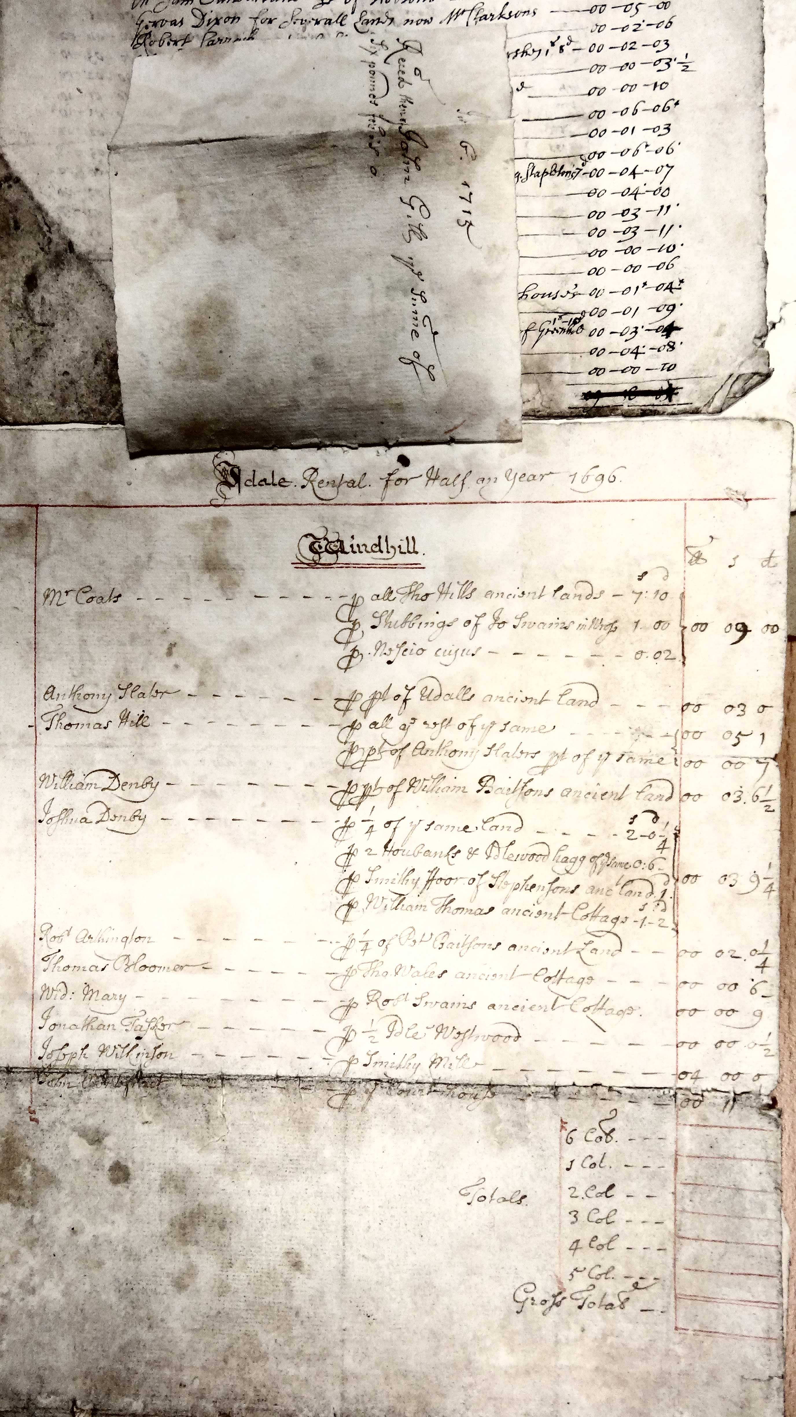
or church (tithe) references and only a few references in the rental books and court rolls, these being chiefly from
the late 16th and early 17th centuries. The Rent Book of 1653 shows that Samuel Bateson was probably the last member
of the Tudor family to possess a lease on land in Windhill. [1]
Since such records were exclusively populated by yeomen and others who occupied freehold or copyhold land, it is
clear that by the mid-17th century the Tudor Batesons no longer held land in Idle, either because the family had fallen on
hard times or because the male line had died out.
There remains the possibility that the female line survived in the area; unfortunately, there are only a few records.
Here are three early ones:
The following section is a history of the property dealings of the early Windhill Batesons.
16th – 17th centuries The line of Windhill Batesons began with Peter in the 1540s and ended with Samuel in 1653.
Giles, Andrew, William, Christopher, John, Brydgett, Jane, Leonard and Abraham, the children of Peter Baytson,
appeared in the Calverley register, in property documents and in wills written at the time.
They lived in Windhill, Wrose and, possibly, Bingley.
PROPERTY The Bateson name was attached to several property transactions for which written records have survived.
Citing the Cumberland Survey of the
Manor or Lordship of Idle of 1584,
Cudworth noted that Peter Baytson held 53 acres 2 roods of land, part of a messuage called Windell.
Their holdings added up to over 106 acres, which they agreed to divide equally between them.
Land transfers The Lordship of Idle was shared between George Clifford (3rd Earl of Cumberland), Sir Anthony Thorold and William Reyner.
The rents from the Windhill messuage were due to the last two gentlemen and their wives, who granted an Indenture of Lease to Peter Bateson
for 1¾ oxgangs of land and buildings. In the 1584 Survey, the date and the term of the lease were left blank, as if the author
was unaware of the details. Since some of the other leases recited in the Survey were dated to the early years of Elizabeth's
reign, it seems possible that the Bateson lease was at least as old, and may even have preceded the Queen's accession in 1558.
[3]
Their holdings added up to over 106 acres, which they agreed to divide equally between them.
He reported that between 1579 and 1589 the 3rd Earl sold the entire Windhill tenement, including the Henbanks and
adjoining land, to Thomas Scott, a Clothier from Oxenhope, and Hugh Yewdall of Windhill for £94 10s.
The sales comprised Broad Ing, Mere Flatts, Mere Flatt Holt and Old Royd, which together would have amounted to about a third of
Peter Bateson's original holding.
The following are possible locations for the Hagge:
In the 1591 tale of a feud
between Robert Swaine and Edward Cage, Christopher Baitson and his brother William
were involved in a violent incident that reached the Star Chamber in London.
The court papers describe Christopher as the owner 'of 3 parts of 2 parcels of
wood ground, parcel of Idle Wood'. This was probably Bateson's Hagge. The story also states that he was a yeoman from
Windhill and that he and William, a husbandman, were brothers. See Horsfall Turner p 69. [6]
William's name appears in the 1696 Rent Book where land tenanted by William Denby was
described as William Baitson’s ancient land, at a rent of 3s 61/2d.
It was John Baitson's son Samuel who continued the Bateson line well into the 17th century: On 7 Jan 1646, Samuel Bateson of Windhill, described as a Yeoman, was a party to a Bond for the payment of £200.
[9]
He was also a Juror in the Idle Baron Court of 2 Dec 1646. [10]
His name was also mentioned in many of the Rent Books [1] compiled for the
Lord of the Manor between 1630 and 1653 as the holder of land that was formerly
Peter Bateson’s. There is therefore a possibility that Peter was his great-grandfather.
The only known heir, Samuel’s son Samuel, was baptised on 27 October 1651.
There are no further records, except perhaps for a burial of a Samuel Baitson in Menston in 1654.
Observations on field names
OTHER BATESON RECORDS A Robert Baitson was baptised to George Baitson of Wrose on 14 November 1596.
Nothing more is known of either father or son.
A John Bateson was baptised to William Bateson of Windhill on 29 September 1695.
His mother was probably Sarah Booth, having married William 5 months earlier.
There is no record of William's baptism in Calverley, though a William Baitson
was baptised in Guiseley to Henry Baitson (b 1618) in 1667.
A John Baitson and others were parties to an action brought against a Samuel
Feather concerning a dividing wall between Mill Lane (aka Swaine Lane, probably the track that led to Buck Mill
on the River Aire at Thackley) and a close called Rough Ing. The action was settled on 23 February 1725. [12]
This may have been the son baptised to William Bateson (and perhaps Sarah Booth) in 1695.
CONCLUSIONS
These scant records provide a faint (and inconclusive) indication of a link between the 16th century
Peter Bateson and the 19th century Joseph Bateson. As Cudworth wrote, 'We believe the link is missing connecting the present Batesons with the Peter Bateson of 1580,
but the coincidence of the still existing name is strong presumptive evidence of a former connection'. [2]
With so few Calverley records, the possibility that the Batesons came to Windhill by way of
neighbouring parishes has been explored.
A few other Bateson families are known to have lived in Farsley, Idle, Otley, Menston, Guiseley, Yeadon, Rawdon and Horsforth.
Although no connection to the Windhill Batesons has been found, they are mentioned in some detail in the footnotes of
Joseph Bateson's page.
NOTES & REFERENCES
Farther Old Royd and Near Old Royd, totalling 9 acres, may have been contiguous closes, perhaps those known from the 1847
Tithe Survey as Royds, Near Royds and Far Royds, which together amounted to 9 acres 18 perches.
All were on the slope below Idle Hill, an area known today as Low Ash [11].
Land in medieval England could be Freehold, Copyhold or Leasehold.
Books detailing the rents paid to
the Manor of Idle are available from 1614 to 1782 [1].
1¾ oxgangs of land of the other moiety of a messuage called Windell.
It was shared with Hugh Yewdall and amounted to 54 acres, 3 roods and 28 perches for which
they each paid an annual rent of 16s 2d. He was probably a copyholder,
paying rent to the Lord. Copyholders could, upon the payment of a 'fine', extend their leases and pass them down the generations. The factors who collected the rents adhered to the
naming conventions established by the 1584 Survey until well into the 18th century.
In the 1630 Rent Book,
Samuel Bateson owed 8s 1d in rent, indicating that he occupied half the
original holding. Messrs Smith, Elliston, Dickinson and Craven paid a total of
8s 0d for land that elsewhere was described as Bateson’s Land, hinting that
this was the other half of the holding. In 1631 and 1635, the
Rent Books make it clear that the land was formerly Peter Bateson’s. After Samuel’s death around 1654 ,
the land was referred to as Peter Baitson’s Ancient Land, a reversion to its
title in the early 1600s. In 1687, in a reprise
of the 1584 Survey, Peter Baitson’s extensive lands in Windhill were listed.
The occupiers were William & Joshua Denby and Robert Arthington.
The Henbanks and Idlewood Hagg of Peter Baitson’s anc (= ancient) land were also mentioned. In 1696, the Rent Book
of that year described the above holdings as William Baitson’s ancient land, William being one of Peter Baitson’s five sons – proof,
it would seem, that William had acquired his father's land.
In Rent Books
compiled in 1715 William, Robert & John Denby and Robert Arthington were
described as the occupiers of Baitson’s Ancient Land. The Arthington family rented one fourth of the land until at least 1782.
The term 'hagge' was not used in the 1584 Survey; it was first mentioned in the 1616 sale of Bateson's Hagge to George Nelson.
In 1593, William, Andrew and Abraham Baytson bought a messuage (a dwelling house with land and out-buildings) and 2 cottages
with lands in Yeadon from William Burneley [16].
These three names appear in the Guiseley parish registers, although only as parents.
They were probably born between 1550 and 1575 and are presumed to be brothers.
His son John was mentioned in the 1651 deed and his grandson Abraham in a deed the following year,
when a rent of one red rose was to be paid for the property.
William Baitson's father or grandfather may have been Xpofer (Christopher) Baytson (there are no records linking the two).
In 1525 Christopher Baytson was assessed at a tax of 8d in Henry VIII's Subsidy Roll for Villa de Yedon [18].
On 26 March 1539, Christopher Baytson was listed in the muster roll of the township of Yedon (Yeadon) in Skyrack Wapentake as a billman with hafe
harness (partly armoured) [18].
In the 1539-40 Esholt Court Rolls, Christopher Bateson was the tenant
of several closes and farms in Guiseley & Menston, including Sym Croft in
Nether Yeadon (10 acres+), owned by Richard Duke, and High Royd in Menston (9
acres) [19].
Christopher probably still occupied the land on 6 March 1545 when a
messuage, barns and lands in Yedden, described as lately belonging to Esholt
Priory in the tenure of Christopher Bateson, were transferred to Edward Hoppey
of Halifax from Richard Duke of London [19].
Among the 22 names listed in the Sessment of Yeadon (Charles I’s tax) recorded in Guiseley
Parish register in 1627 were an Andrew and Abraham
Baitson, who were assessed at 4d each.
There was also a John Baitson, who was assessed at 2d [18].
These three – Andrew, Abraham and John, together with William and Christopher, are thought to be members of
the Yeadon family of Batesons referred to above.
A Christopher Bateson was noted in a Conveyance of various Rent Charges to Baildon Chapel dated 24 October 1638.
He was the occupant of five closes of land in Baildon, namely Overcrofte, Narr Lather Banckes, Far Lather Banckes
[Near and Far Ladderbanks], Lower Broachfeild, and Feild Close. These fields amounted to 'Six acres a half and one Roode'
and were worth an annual rental of 13s 11d. Christopher was probably the tenant [20].
Christopher may have farmed the land rather than lived on it; since Otley parish in the 17th century included both
Baildon and Menston, it is likely that this was Cristofer Bateson of Menston, who died in 1663.
There were two other Bateson males associated with Menston in the mid-17th century:
REFERENCES 1 See Rent Books refs: WYL500/809-820, MMC/58-65, 21D88 in W Yorks Archives.
See sample image & sample Rent Book
transcriptions 2 'Round About Bradford' by William Cudworth,
Thomas Brear, 1876 pp 400-404 3 'Survey of the Manor and Lordship of Idle, 1584', from a copy in W Yorks Archive 23D98/8/1
4 'Survey & Valuation of the Township of Idle' by Jonathan Taylor, 1814.
See Windhill and Thorpe & East map extracts
5 p19, 'The Cliffords, Earls of Cumberland, 1579-1646s, a study of their
fortunes based on their household and estate accounts',
by RT Spence, 1959
7 Document No WYL500/138 in Stansfield Muniments in W Yorks Archives.
See transcription and scan 8 Document Nos WYL500/141a & WYL500/213 in Stansfield Muniments in W Yorks Archives
9 from Jowett Family Estate records No JOW/2/59 in W Yorks Archives 10 'Idlethorp' by Wright Watson, Bank House Media, 2009 p 66 11 'Plan of Idle (Tithes)' by W Wordsworth, Blackgates, 1847.
See http://wytithemaps.org.uk/maps/idle/ 12 in Stott-Stanhope Manuscripts in W Yorks
Archives ref: StSt/2/254 13 'Copyhold Tenure and its Survival in Holderness in the East Riding of
Yorkshire from c.1750 to 1925', by MT Craven, University of Hull, 2002 14 The Bradford Antiquary, Vol 1, 1888
15 taken from Berwick Collection published by
Yorkshire Archaelogical Society, also in Stansfield Muniments in W Yorks Archives 16 from 'Yorkshire Fines: 1593', Feet of Fines of
the Tudor period [Yorks]: part 3: 1583-94 (1889), pp 186-201 17 Settlement: William Bateson of Eavesey
in Yeadon husbandman to John Collier and Abraham Bateson of Yeadon, yeomen:
18 listed in 'Yeadon, Yorkshire', by T Illingworth,
1980 19 from Esholt Priory Estate Accounts, 1539-40 in
Bradford Antiquary New Series Vol 4 20 in 'Baildon and the Baildons'
Vol 3 p178 by W Paley, Lund Humphries & Co, 1924 © Windhill Origins
In the final quarter of the 16th century the Calverley parish registers recorded one,
perhaps two,
Bateson families in Windhill with another in nearby Wrose.
Between 1602 and 1695 there were only three records - all baptisms.
The next fifty years yielded no Bateson records at all.
From 1746 to the end of the 18th century there were around two dozen Bateson references in the registers but
the abodes were mostly in Idle - only six were from Windhill.
The registers are otherwise complete.
The absence of church records points to the latter conclusion.
Alice Baytson, Giles Baytson's widow, married Robert Nussay in Calverley on 12 October 1596. In 1573 a Robert Nussay of
Pudsey was granted a rood of land by Walter Calverley. There are no other records for this couple.
Sybill Baytson, Christopher Baytson's widow, married Robert Craven in Calverley on 8 December 1596.
A Robert Craven held land in Wrose but is not thought to have had a connection with the Batesons.
Isabell Baytson, born to Christopher in 1594, married Francis Gledston in 1611. They probably lived in Idle - a Francis Gleadston
was a pew holder in the Old Chapel, Idle in 1634. And a man named Gleadston paid rent on part of Samuel
Bateson's land in 1631.
This is followed by a brief review of Bateson families who lived elsewhere.
Peter was born in the 1540s, married Jane and died in 1584/85.
Giles, his eldest child, married Alice, but had no children surviving to adulthood. He died in 1595.
Andrew, along with Christopher, had a share of his father's property, which he sold in 1589.
William, along with Christopher, was involved in an infamous incident in 1592 that led to a court case. He had two children, Grace and John.
Christopher inherited around half his father's lands. He married Sibill Cowper and had three known children:
Agnes, Andrew and Isabel. Isabel, the only child to reach adulthood, married Francis Gledstone in 1611 and sold part of her
inheritance, Bateson's Hagge, in 1616. Christopher died in 1596.
John married Isabel Longe in Bingley in 1592. He died in 1617. Of his four known children only Bridgett and Samuel survived to adulthood.
It is possible that the latter was the Samuel Bateson of Windhill who appeared as a Juror in the Idle Baron Court of 1646.
Of Peter’s female children, Brydgett and Jane, nothing is known.
Leonard and Abraham were baptised in 1575 and 1578 respectively but nothing further is known.
Some were mentioned by William Cudworth in his volume Round About Bradford, published in 1876.
[2]
According to the Survey, almost the entire Windhill messuage was leased to Peter Bateson and Hugh Yewdall.
[3]
Each man paid to the Lord of the Manor an annual rent of 16s 2d.
The Survey contained lists of each man's holdings, together with information about their leases.
Peter Bateson's holdings, known as 'closes', are tabulated below, along with the descriptions and
areas given in the Survey.
Their locations, where known, have been appended.
This map is said to have accompanied the Survey.
Close
Description
acre/rood/perch
Location
Farther Old Roide
below Idle Hill
Near Old Roide
below Idle Hill
Far Hirst
Wood Hirst
being woody ground
Near Hirst
divided into 2 parts
E of Wrose Brow Rd
High Ing
woody ground
Fox Cliffe
2 x broom closes
Windhill Wood?
Broad Ing
1 close of arable & meadow
Mere Flatt Holte
Peas lands & 2 Mere Flatts
The Carr
1 close of bushie ground
above Woodend
Henbanks
site of Windhill Station
Total area
Some of these holdings, those that have been conclusively identified, are shown overlain on the 1847 OS map.
Field names used in the 19th century have been added to these extracts from the
plan
produced by the 1814 Survey [4]:
Windhill & Wrose; Thackley & Thorpe.
Additional information on the holdings listed in the table
above are presented in the Notes & References at the foot of the page.
The 1584 Survey suggests that almost the entire Windhill messuage was leased to Peter Bateson and Hugh Yewdall.
[See also Notes on Tenure below ]
The records show that they each paid to the Lord of the Manor an annual rent of 16s 2d, a figure that would be maintained for the next 200 years.
But the pair actually shared Windhill with two other men: the holdings of Thomas Hill, amounting to at least 28 acres,
and those of Richard Lillye, comprising two iron works, were also listed as part of Windhill.
In a further complication, Cudworth wrote,
"We have before us a bundle of old deeds relating to the Windhill property of the last Earl of Cumberland".
[2]
This may have been part of the sale, in November 1585, of Cumberland's moiety of the manor of Idle for at least £400.
[5]
Cudworth's deeds have not been located, so cannot be checked.
His findings seem to contradict the fact, noted above, that Peter Bateson acquired his half of Windhill from
Messrs Thorold and Reyner and their wives at some date before 1584.
The Survey also records that both Hugh Yewdall and Richard Lillye acquired their holdings from leases originally
granted by Sir Ingram Clifford, the 3rd Earl's uncle.
In the context of accuracy, it is worth noting that the writer of the 1584 Survey expressed gentle frustration at the
difficulty in getting hold of some of the documentation, particularly conveyances issued by Messrs Thorold and Reyner.
He also complained that listing all the grants made by Sir Ingram Clifford would have involved much labour "to small purpose".
[3]
Andrew & Christopher Baytson inherited the bulk of their father Peter's holdings in Windhill when he died around 1584.
John Baytson somehow acquired Far Hirst and passed it on to his son Samuel.
It is not known who inherited the Henbanks.
However, Horsfall Turner reported (page 70) that by 1592, Edward Cage, a London grocer, was the lessee of the Henbanks,
which he enclosed and used to store charcoal. [6]
In 1589, Andrew and Christopher, sold 15 acres of land in Windhill to Thomas Scott, "in consideration of the sum of twenty pounds lawful money".
[2]
Most of the remaining closes - Near Hirst, Wood Hirst, High Inge, Carr and Farr Fox Closes (thought
to be another name for Fox Cliffe)
- were eventually passed down to Christopher's daughter Isabel.
Skelbroughe
Peter's Will
also bequeathed his "farmeholde or tenement" in a place called Skelbroughe to his wife and children.
Skelbroughe, Skelbrook(e) or Skelbrowke was a chapelry in the parish of South Kirkby, between Doncaster and Pontefract, about 40 miles from Windhill.
This might have been an inherited property, in which case the Batesons could have originated in the area, or it might have been a
speculative purchase: either way, this researcher has found no other references in the historical record.
William Pickard of Menston and Thomas Cave of Wakefield, the latter described by Peter as "my faithful friend", were to arrange the conveyance
of the Skelbroughe property. Cave, born in Burley in Wharfedale around 1551, was a cloth merchant and property speculator,
with holdings in the Wakefield area, Farnley (near Otley) and other parts of Yorkshire
(though not in Skelbrook). He was a founder of Otley Grammar School and
a benefactor of Wakefield Grammar School. He died in 1603.
What became of the Skelbroughe tenement after Peter's death is not known.
Bateson's Hagge
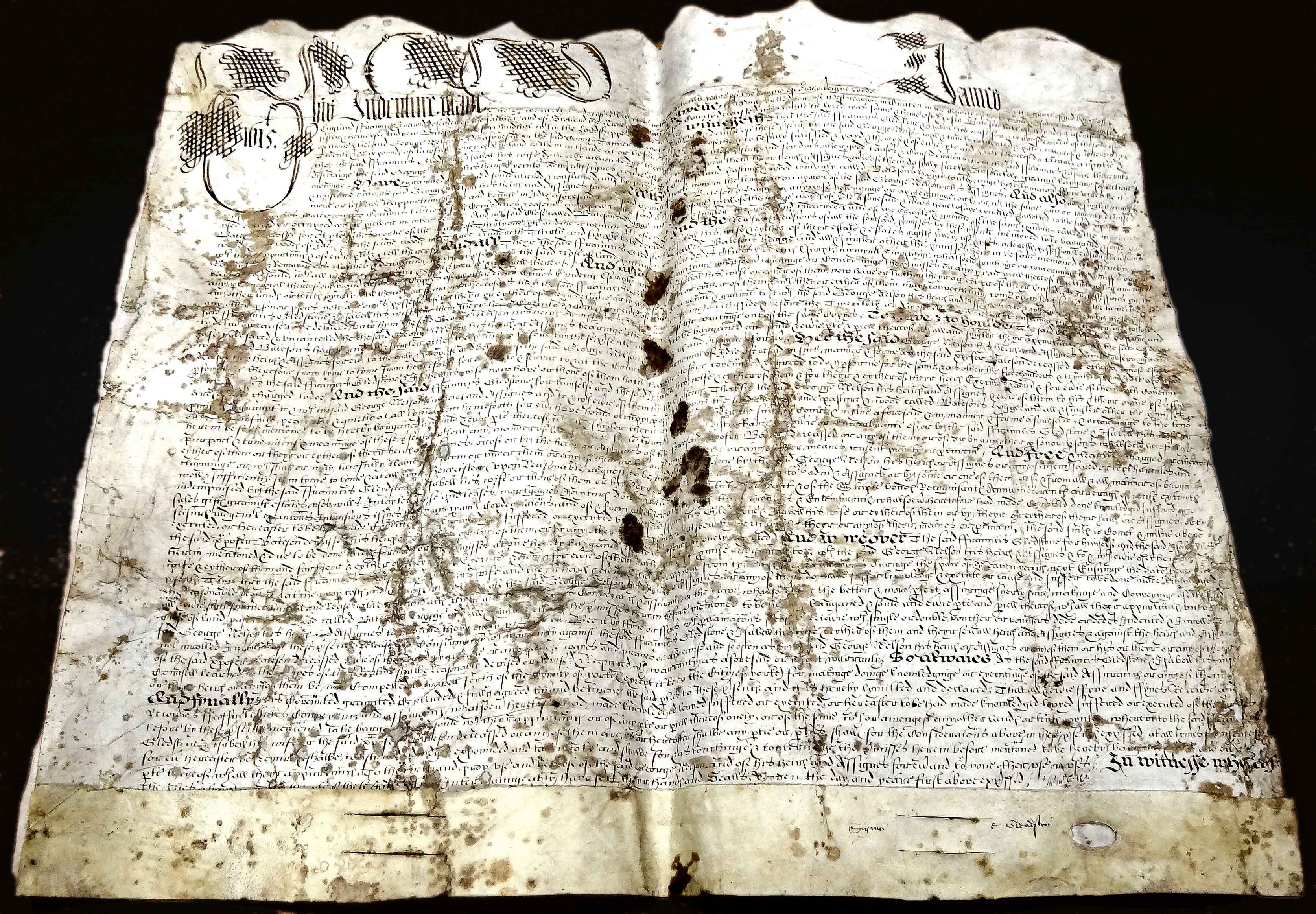
In 1616/17 Isabel Baytson and her husband Francis Gledstone sold 5 acres of land called Bateson's Hagge to a tanner called George Nelson.
[7]
See transcription and scan.
A hagge was a small wood, sometimes including pasture, which was walled or hedged and often used for coppicing.
It was immediately sold on to Richard Lillye, who operated the iron smithies on Bradford Beck. The timber may have supplied charcoal for his furnaces.
At some point before 1687, Lillye, or his heir, sold the Hagge to James Hobson whose son John sold it back to the Lord of the Manor, Sir Walter Calverley,
in 1710.
[8]
The land was still known as Bateson's Hagge, however.
Yet it was not mentioned by name either in the 1584 Survey or in the Rent Books of the Idle Manor, which extend to 1723.
But it was sometimes referred to as the Idlewood Hagg. As such, it was recorded in the Windhill section of the Idle Manor
Rent Books as part of Peter Bateson's 1584 lands.
[1]
1) In the 17th century, the Hagge was variously described as part of the Idlewoods, the Maynewoods and the Outwoods.
It appeared in the 1687 and 1696 Rent Books as the 'Idlewood Hagg of Peter Baitson's ancient land'.
It was listed, at a rental of 6d, along with the Henbanks, suggesting a location in north-west Windhill.
A likely site would be the western end of the West Wood at Woodend. See map showing its possible location.
By 1814 this tip of the West Wood had become detached from the main wood and was known as Windhill Wood.
At that time the 3 closes that made it up totalled just 6 perches short of 5 acres, roughly the size of Bateson's Hagge.
2) In 1584 Tristram Lyllye (father of Richard) was tenant of a large close in north-east Thorpe called Sinder Carr
while Edward Grenehall held one called Sinder Carr Inge; together the two closes totalled 7 acres.
The Sinder Carr properties were part of the 1710 Hobson/Calverley land sale that included Bateson's Hagge. [7]
This association of the two closes implies their proximity.
The 1814 Survey mapped six closes with Sinder (or Cinder) Carr and Hagg in their names.
They were clustered around a small wood - Round Wood - near the present-day Poggy Wood and (in 1814) had a combined area of 15 acres 2 roods 29 perches.
This matches, to within 1¼ roods, the figures given in the 1710 deed.
There were two 'Hagg' closes in 1814: 'Broom Hills Cinder Carr and Hagg', and 'Hagg'.
Their combined area was 5 acres, 3 roods, 4 perches.
See map.
It could be that Bateson's Hagge comprised the greater part of these two closes.
However, the main difficulty with placing the Hagge in north-east Thorpe, which is 2 miles from Windhill, is that the 1584 Survey
assigned Peter Bateson's holdings solely to his half of the Windhill messuage.
In addition, yeomen in 1584 mainly held land in their home villages and occasionally in adjacent villages.
None seem to have had fields that were more than a mile or so from their home villages.
For additional information on Bateson's Hagge see this footnote.
William, son of Peter Baitson, had not been bequeathed any land, either by his father or by his brothers Christopher and John.
This Rent Book description suggests that somehow he acquired at least some of his father’s lands.
Samuel probably died in 1653 – the 1654 Rent Book noted that the land was being farmed by the Heirs of Sam Bateson.
* The map that is said to have accompanied the 1584 Survey was not detailed enough to show individual closes,
though some large holdings, such as West Royd and features such as Eshing Cliffe, were marked.
* Rental and tithe records from the 17th and 18th centuries usually identified land holdings by the name of the
owner, past owner or present occupant and only occasionally gave the names of the closes.
* The constructions of the first turnpike road in 1754, the Leeds Liverpool Canal in 1774, the new turnpike road in 1827,
the Leeds to Bradford railway in 1845 and the Shipley to Idle branch line in 1874 would have disrupted a number of land holdings
in north Windhill.
* Some field names from the 1584 Survey can be found in later surveys. Birk Royd (held by Hugh Yewdall), for example,
was known as Low, Middle and Upper Burk Royd in Jonathan Taylor's 1814 Survey [4] and as Low, Middle and
Upper Bank Royd in the 1847 Tithe Survey. [11]
Generally, though, field names had changed so much by 1847 that only a few correspond to those of 1584.
* A few names are preserved on today's maps:
Carr Lane, West Royd, Woodend and Henbanks (the site of the Windhill railway stations) are all within the borders of today's Windhill.
The Holt is a street at the foot of Carr Lane in Windhill where Joseph Gawkrodger was said to have first preached the Baptist faith in 1752.
Other names, such as Dirlings, Laverack, Miln Holme, Eller Carr and Briarfield, can be found in Wrose, Thackley, Thorpe and Idle.
The Guiseley, Yeadon, Menston and Baildon Batesons
There were Bateson families in both Guiseley and Otley.
One, from Yeadon, had property interests locally and in Manningham, Bradford. Their names (William, Andrew, and
Abraham) were the same as three of the Windhill Batesons. There was also a Christopher and a John, though they
were William’s sons. Whilst Giles and Leonard, the names of Peter's two other sons, were absent from the Yeadon
property records, a Lenard Bateson was buried in Guiseley parish on 1 May 1595.
The similarity of the names is believed to be coincidental: no connection with the Windhill Batesons has been found.
Likewise, there are no obvious links to Bateson families in Otley parish.
There is more detail about these families
in this footnote.
18th and early 19th centuries
Notes on the Bateson lands
Near Hirst was described by the 1584 Survey as "divided into 2 parts".
The 1847 Tithe Survey identified a long, narrow close east of Carr Mires Beck as Near Hirst.
It had an area of 2ac 2r 36p. To the south a close called Far Hirst was 1ac 2r 13p.
However, in 1814, these two fields were undivided, a single field called Hirst, with an
area of 4ac 2r 4p.
This is almost 3 roods short of the size of the Near Hirst of 1584.
Wood Hirst and Far Hirst have not been positively identified. In 1847 there were four other closes adjacent to
Near Hirst with 'Hirst' in their names so Wood and Far Hirst were probably located hereabouts.
High Ing, a close of woody ground, has not been identified: there were no closes of that name in the 1847 Survey.
Fox Cliffe has not been positively located. This researcher can offer 3 possibilities:
A) The name may have referred to the western part of the Wrose Brow cliffs between Carr Lane and Carr Mires Beck,
since its acreage (10ac) exactly matches that given for the corresponding area shown in the 1847 Tithe survey.
By contrast, the cliff that extends eastwards from Carr Mires Beck under Idle Hill was known as Eshing Cliffe
and was marked in roughly that position on the map that accompanied the 1584 Survey.
Today this is a mixed woodland comprising a plantation of birch, sycamore, lime, pine, larch, oak and beech,
with a few of the last two species being around 200 years old.
The ash trees that once gave the woodland its name (Eshing) are conspicuous by their scarcity.
In 1584 it was described as a "close of Woody ground called Eshing Cliffe .... vallued at 33s:4d y Acre",
suggesting that the steep slopes supported woodland, possibly oak, of considerable value to the Manor.
Fox Cliffe, on the other hand, was not given a value by the Survey.
This supports its description ("2 brome closes"), which suggests a low quality Cytisus (broom) scrub that could be
harvested for fuel.
The difficulty with placing Fox Cliffe on Wrose Brow is that the latter was common land: "Wrose Browe is a parcell of
comon lying near unto the Town of Wrose the same is likewise but barren ground & containeth by estimacon twenty Acres".
As common land, it was unlikely to have been leased to an individual tenant.
Further east, Eshing Cliffe was, by contrast, leased to Thomas Stable and was therefore almost certainly enclosed.
It was probably part of a zone marked on the 1813 Inclosure Award map as 'Ancient Inclosures'.
At the time of the 1847 Tithe Survey it was known as Dirlings, a name that survives in the area to this day.
Wrose Brow, despite having a similar topography, was not enclosed until 1813, when it was allocated to
Messrs. Joseph Dawson, Joseph Hobson and Eamonson & Dinsdall.
There is a note on enclosure with particular reference to the Idle Inclosure here.
B) Fox Cliffe may have become known in later years as Bateson's Hagge, which is discussed in more detail
here. A possible location was the former Windhill Wood that lay between Woodend and Woodbottom
(between Thackley Old Road and the lane known as Walker Place). On its north side a wooded river cliff drops down to
the old Idle and Shipley Railway. The 1814 Survey gives an area of almost 5 acres for the Wood, whereas the
1584 Survey has 10 acres for Fox Cliffe. The addition of fields bordering the River Aire, such as Far Gill and
Broom Close, could have brought the total area up to 10 acres.
C) An area to the north-east of Thackley, near today's Poggy Wood. See Para 2 of the Bateson's Hagge discussion here.
Broad Ing has not been identified.
Looking at the possible candidates, Ing and Carr (adjacent to the Hirst closes) fall ¼ acre short.
On the west side of Carr Lane, Ing and Little Ing together amount to 1¾ acres short.
To the north of the turnpike road, two closes called The Ing and Ing in 1814 together amount to 72 perches
(nearly ½ acre) too much.
Mere Flatt Holte: a holte was usually a wooded area. There is a short street called The Holt at the foot of Carr Lane.
Pease Lands and Mere Flatts have not been identified.
A pease field presumably grew legumes.
The Mere Flatts were probably near the river, where there were likely to have been ponds.
Flatts originated in the old ridge and furrow field system and were arable fields a furlong in length.
The Carr was a close of 2½ acres of "bushie ground". Although the name often refers to swampy woodland
scrub consisting of willow or alder, the only occurrences of the name (5 in total) in the 1814 Survey & Valuation
[4] and 1847 Tithe Survey [11] were on the steep slope below Wrose Brow.
Henbanks was a 4½ acre pasture near Bradford Beck on the road to Shipley. In the late 18th century, it was cut into
two parts when the Bradford Canal was dug. In the 1870s the Windhill Passenger and Goods Stations were built on the
three closes that made up the site.
Notes on Tenure
Freeholders could acquire and dispose of land in whichever way they chose. According to the 1584 Survey, there were none in Idle.
Whereas Freehold land was owned absolutely, Copyhold land was owned by the Lord and the Copyholders were his tenants, paying a fixed rent.
In practice, however, Copyhold land could be bought, sold and mortgaged, just like Freehold land. It could be held by the same family for
generations, subject to a fee being paid to the Lord every time there was a change of tenant or Lord.
According to the 1584 Survey, at least some of the Lord's tenants held their land by "Copie of Court Rolle" - they were Copyholders.
Leasehold tenancies were granted for a period of time. This seems to have been the predominant form of tenancy in Idle
at the time of the 1584 Survey. This was also the position in the Clifford lands of nearby North Craven, where the lease of a tenement
terminated on the death of either the tenant or the Lord.
However, on Clifford lands in East Yorkshire leases were mainly Copyhold, despite attempts by the Cliffords to convert them to Leasehold [13].
It has not been possible to work out how many Idle tenants were leaseholders and how many copyholders, largely because the writer of the 1584 Survey
did not have access to all the necessary documentation.
Some tenants, such as Thomas Stable, leased their holdings for a life term.
Others were tenants for fixed terms: Edward Swaine had 60 years; Edward Waterhouse had 41 years; Richard Lillye and many others had 21 years.
John & William Bucke were granted two leases for Idle Mills in Buck Wood for terms of 21 years and 60 years: the
Bradford Antiquary's transcription of the 1584 Survey [14] contains a note that the Buckes claimed the mill as Copyhold when
the Calverley family bought the manor in the early 18th century.
At least two holdings were for unspecified periods (Hugh Yewdall) or none at all (Peter Bateson) and these look more like Copyhold than
Leasehold tenancies.
Other holdings, particularly cottages, were 'At Will' (of the Lord), so could, presumably, be terminated at any time.
After 1585 when the 3rd Earl was trying to raise cash, most land transfers were by feoffment, bargain and sale or lease
and release. These were terms that usually indicated Freehold property.
These conveyances included transactions involving the Buck family, the Swaines, Hugh Yewdall and the Bateson family.Notes on the Rent Books
In 1614, Peter Bateson’s Windhill property comprised:
In 1614, for example, two of the holders of land in Windhill were named as Hugh Yewdall and Peter Baitson, each of whom owed 16s 2d in rent.
Peter probably died in the 1580s and Hugh certainly died in 1604, yet the old names, measurements and valuations
were still being used.
Notes on Bateson's Hagge
Over the next 80 years, at least 10 uses of the term were recorded in various deeds.
The names of the owners or tenants were often attached to some of these hagges, perhaps because they were newly designated.
This is a list of conveyances involving hagges [15]:
Bateson's Hagge - bargain & sale from Francis & Isabel Gledstone to George Nelson of Idle, tanner - 20 March 1616
Bateson's Hagge - bargain & sale from George Nelson to Richard Lillie of Thornton, yeoman - 24 Nov 1617
Hagg - bargain & sale from Mary Blagburne of Idle, widow to Samuel Hobson of Idle, clothier - 8 Feb 1632
The Hagge - tithe sale from John Midgley of Headley, gentleman & Tristram Kitson of Calverley, yeoman to John Brooke of Idle, skinner - 5 Oct 1635
Brooke Hagg - bargain & sale from John Midgley of Wilsden, tanner to Walter Stanhope of Horsforth - in Idle [woods], formerly in
occupation of George Nelson - 27 Jan 1636
New Hagge - deed of gift from Ralph Swayne of Idle, yeoman to William Swayne of Idle, clothier - 8 Jun 1652
Hobson Hagg - deed of gift from Joseph Viccars of Idle, clothier to Joseph Viccars of Idle, his son - 12 April 1673
The Nagg (sic) - marriage settlement between William Dawson of Rocliffe, yeoman and Dorothy Exley of Rawdon -
a parcel of woody ground in Idle - 29 May 1680
New Hagg - lease of possession from William Swaine of Idle, yeoman to Robert Swaine, son & heir -
in occupation of Robert and John Sandall - 17 Jan 1685
Nelson Hagge - mortgage from James Hobson of Idle, yeoman to William Cockcroft of London, gentleman -
in occupation of James Hobson & Joseph Viccars - 14 Apr 1692
Sandall Hagg, Starky Hagg, Jefferey Hagg & Lilly Hagg - lease and release from Thomas Wallis, Joshua Snowden & Elizabeth Swaine
to James Booth and Samuel Swaine, both of Idle, yeomen - 28-29 Nov 1694
Bateson Hagg alias Nelson Hagg - lease and release from John Hobson of Leeds, yeoman to Walter Calverley of Calverley esq. - 22-23 Aug 1710
Starky Hagg - bargain and sale from James Booth of Thorpe to John Booth of Thorpe - of the Wood Close alias Starky Hagg in Idle - 10 Dec 1722
Sandall Hagg, Starkie Hagg, Jeffrey Hagg, Lilly Hagg - lease and release from Alice & John Booth of Idle, maltster & James Booth of Idle, yeoman,
to Sir Walter Blackett of Hill Top in Idle - 23-24 May 1753
Starkie Hagg - lease and release from John & Martha Walker of Calverley to Robert Stansfield - 18 Apr 1770
It is possible that the above hagges (except Sandall Hagg, Starkie Hagg and Jeffrey Hagg) were the same piece of
ground in north-east Thorpe - ie Bateson's Hagge.
Lilly Hagg, Nelson's Hagge, Brooke Hagge and Hobson Hagg all contain the names of people who were linked to the original Hagge
- ie Bateson's.
Notes on the Batesons of Yeadon and Guiseley
One of the brothers, William, appeared in deeds relating to property in Evesay (thought to be in Nether Yeadon) in 1613 and (perhaps) in 1651 [17].
Whether or not he was the Christofer Baitson (b 1596, son of William) of Guiseley is an open question.
Cristofer may have married an Isabel and then a Jane Keighley and had at least 5 children, including four girls.
A son, William, born in 1639, married Mary Shaw in 1668 and had 2 children, both girls.
With his death in 1674, Cristofer Bateson’s line of male descendants appears to have ended.
A John Baitson may have married a woman called Elizabeth Smithe in Guiseley in 1622 and buried her in 1657.
A Samuel Baitson was buried on 11 April 1654.
See transcription
and scans of the pages listing Peter Baitson's holdings
* "clea", a term used in the Bateson / Yewdall sections, was one fourth of an oxgang
* The number of acres that constituted an "oxgang" was not defined - it could be anything from the usual 15 or 16 acres
to the 50 acres thought to have been common in the Bradford area
* The writer of the Survey "could not of certenty sett Downe what Leases Grants or other
assurances have been made by the
sd Wm Thorold & Wm Reyner to the tenants there And to have given notice of all the Grants made by Sir Ingram Clifford
would both have asked much labor and the expressing thereof in this Booke had been to small purpose"
"A moiety to use of W.B. for life, then to his son and heir John. Other moiety to use of J.B., who shall pay £10 each to
Grace, Christopher and Isabel, other children of W.B." dated 25 May 1613, Hull University Archives UDDCV2/77/43
See also Hull University Archives UDDCV2/77/44 and 45