|
Plots and Plans maps of Windhill Crag 1584 - 1934 + ownership history of various plots The Plans
(jump to descriptions of the Plots)
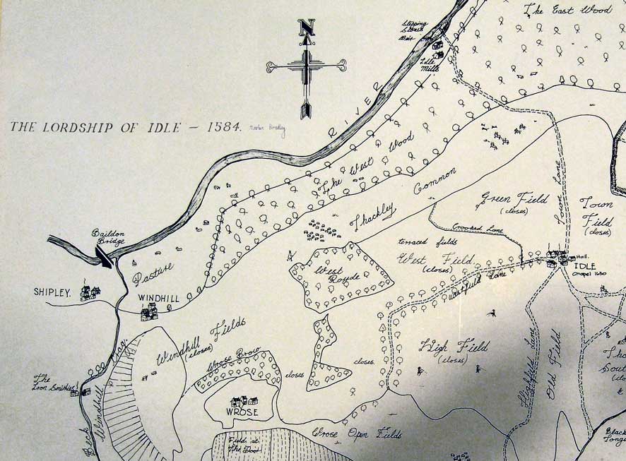
Lordship of Idle – made in 1584 for the Cumberland Survey – adapted by
Martin Bradley 
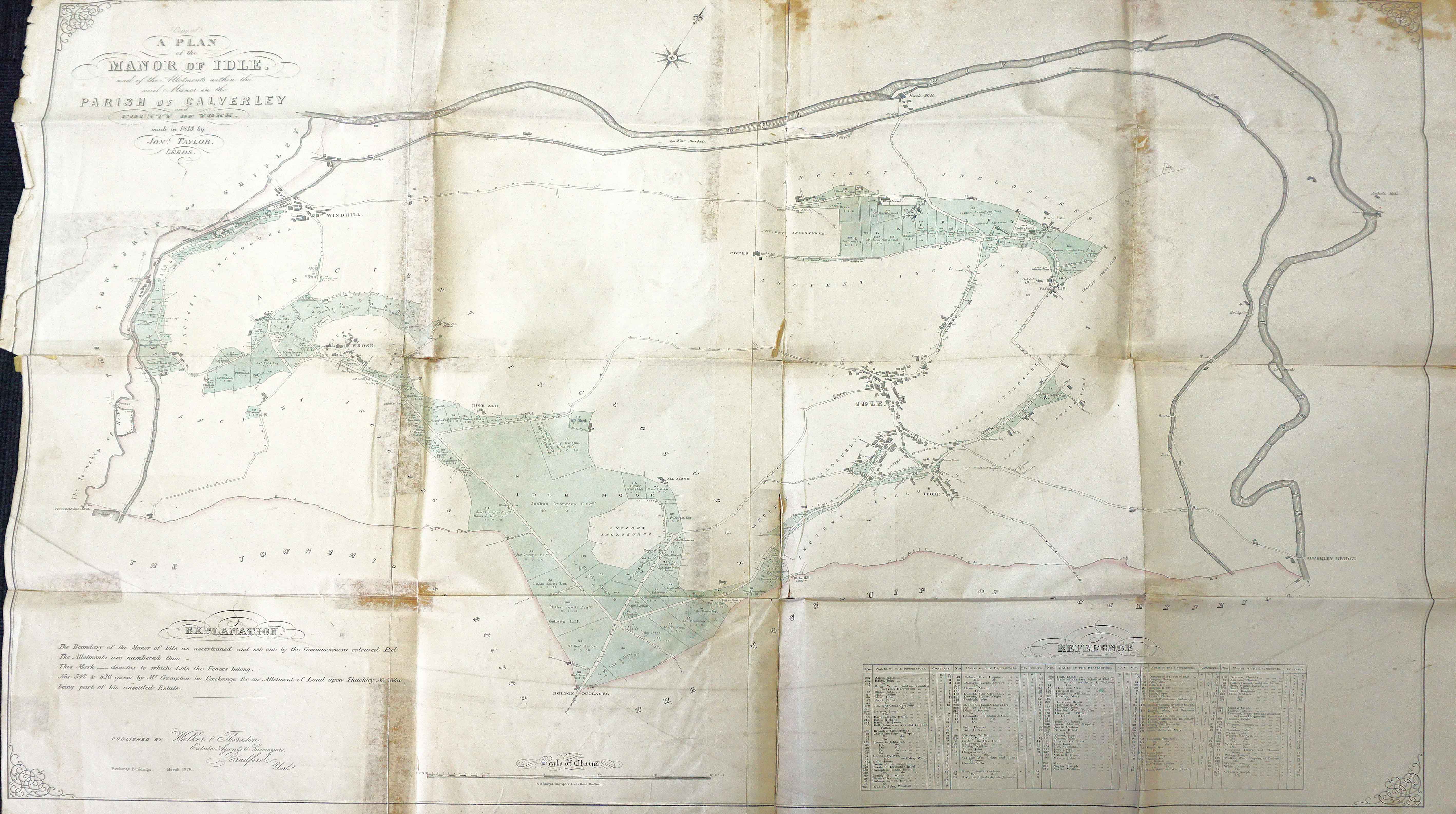
Extract (edited) from A Plan of the Manor of Idle – made in 1813 by Jonathan Taylor,
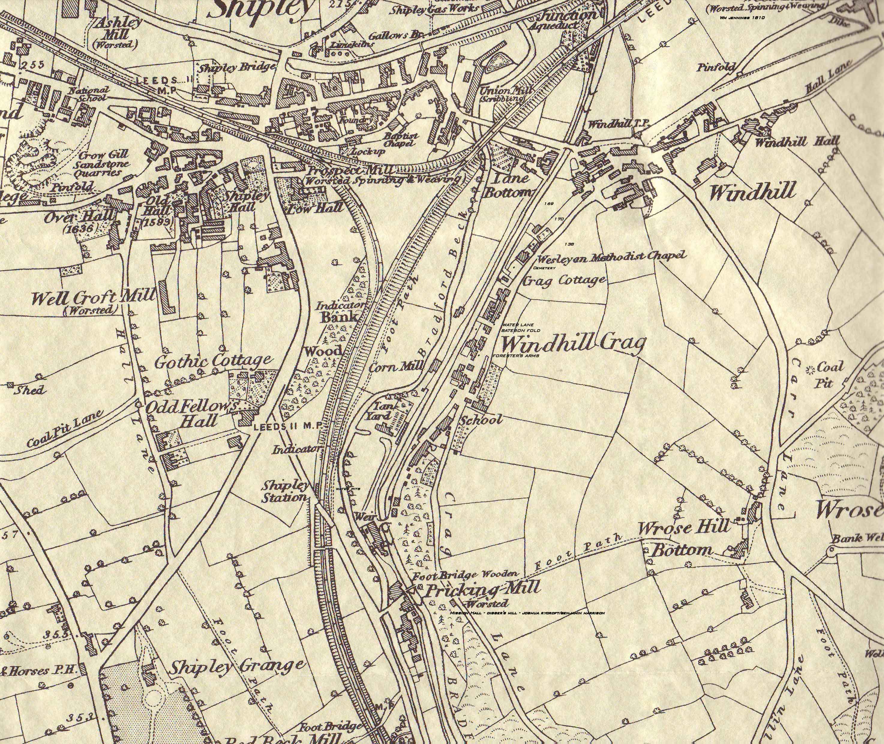
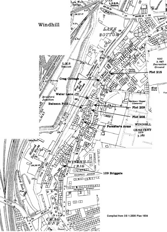
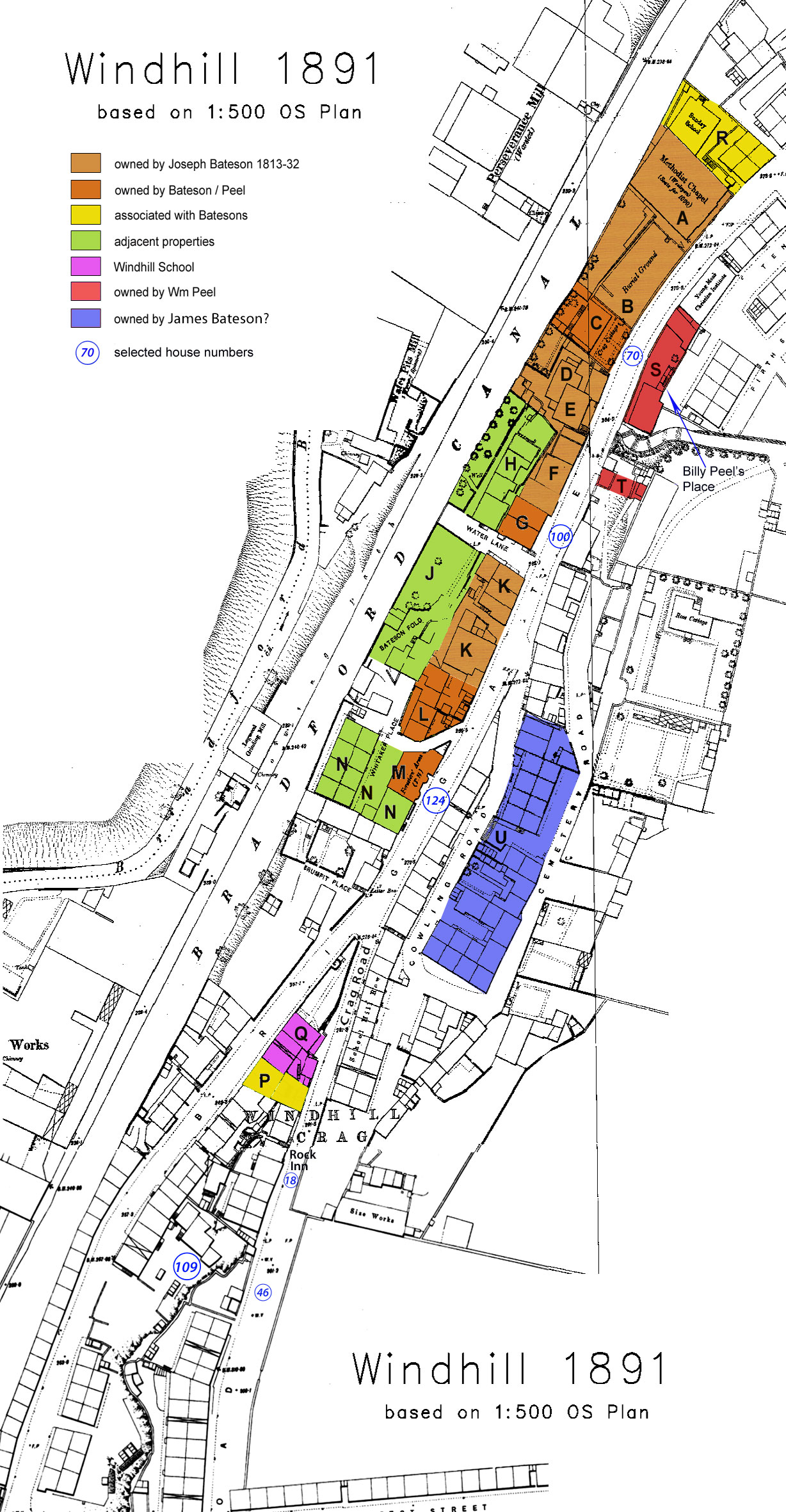
Extract (edited) from OS 1:10,560 Survey, 1847 Compilation from 1:2500 OS Sheet, 1934 Selected properties overlaid on 1:500 OS Plan, 1891 The Plots The plot numbers shown on the 2nd Plan from the top, entitled
'Extract (edited) from A Plan of the Manor of Idle',
were taken from the 1813 Idle Inclosure Notice and accompanying Plan.
This was drawn up between 1810 and 1813 by the Commissioners, Jonathan Taylor
and Jonathan Teal.
Where there was space on the 1813 Plan, the enclosures that were awarded show their areas in acres, roods and (square) perches.
See the note on enclosure in the Footnotes below.
In 1814, Jonathan Taylor and Henry Teal produced 'A Survey and Valuation of the Township of Idle'.
Their new Plan showed every plot of land in Idle and the accompanying 62 page Report gave the size,
use, valuation, ownership and occupancy of most of them.
This writer has added the field names to the north-west and the north-east sections of the Plan.
These can be viewed here: NW Idle and NE Idle.
Some fields were not mentioned in the Report or were given generic names such as 'Field'. In some of these cases,
field names from the 1847 Tithe Map have been substituted, these instances
being denoted by an asterisk: *.
A, B & C (Plot 215) The 1813
Inclosure Plan shows that Joseph Bateson was allotted 3 small plots of land
totalling just over half an acre between the Bradford Turnpike (later Briggate)
and the Bradford Canal. The largest,
designated 215, was a rectangular plot of 2 roods (2420 sq yds or 1/2 acre)
between Briggate and the Bradford Canal. “Purchased
of John Denby”, it was
allotted to Joseph Bateson. A - Wesleyan Mission and B - Burial Ground In
1834-35 the first Wesleyan Mission Hall was constructed on the north-east
section of the site. It was a small one-room
building with no vestry. The entrance was from the cemetery. The
deeds for the conveyance of the land to the Wesleyan Trustees were described in
1960 by J A Stevenson, the author of a typescript entitled ‘Round About Windhill’. The deeds were in
the charge of the Wesleyan Superintendent Minister. According to Stevenson, they state that on 6 Aug 1834 a plot of
land in Bradford Road Windhill was leased from Mr Joseph Bateson for 1 year for
a first payment of 5/- and a final payment of 1 peppercorn to be paid the day
before the end of the Lease. This was standard conveyancing practice at the
time. On 7 Aug 1834 the Lease was terminated and the land transferred to the
Trustees for the purpose of building the Church.
The Release part of the conveyance would have given the price paid for the land,
but this does not appear to have been included in the deeds.
Milton Hudson, in his ‘Windhill Wesleyan Mission Origins’, mentions
2 other conveyances connected with the Methodists. In 1837, he
writes, the Trustees of the Methodist Chapel (Samuel Bradley, Thomas Jennings,
Joshua Parker, Thomas Parker, John Peel and James Wilcock) conveyed land to the
Rev James Wilson, the Superintendent Preacher. The 1838
map shows a large, square building that may be the first Mission Hall – it was
demolished in 1849, when a larger building was erected. C - Crag Cottage The
Methodists used about 30% of Plot 215 for their chapel and 45% for the burial
ground. The
remaining 25% was conveyed to William Peel for the construction of Crag
Cottage. The house was probably built
in 1837 on the southern part of the Plot.
A
Memorial of a Lease and Release written on 11 and 12 August 1834 describes the
conveyance in the following terms: “Lease
& Release between Joseph Bateson of Windhill Cragg, Cloth Maker and William
Peel, clothmaker of and concerning all that plot piece or parcel of ground as
the same is now stated out of and from a certain Allotment situate lying and
being at Windhill Cragg aforesaid and adjoining on the North East side thereof
to a plot of ground lately sold by the said Joseph Bateson to the Trustees of the
Wesleyan Methodist Chapel intended to be erected thereon ”. This almost certainly refers to the
southernmost part of Plot 215, bounded “on
the South West side thereof to the remaining Stripe of such Allotment”. Being a
summary of the original Lease and Release, no details of monetary
considerations or time scales were noted in the Memorial and the purpose of the
conveyance was not revealed. That the
house was Crag Cottage was confirmed in an Indenture dated 31 January 1866, when,
at the instigation of the Official Liquidator of the Leeds Banking Company,
Peel conveyed all his properties to William and James Bateson: “all that dwellinghouse situated at Windhill .. formerly
in the occupation of .. William Peel and the house under the same .. formerly
occupied by one William Naylor, with the workshops and premises .. in the
occupation of John Verity“. Crag Cottage was probably
demolished in 1964 or 1965 - it appeared on the 1960 1:2500 OS Plan and was the
subject of a purchase order by Shipley Urban District Council in early 1964. D - Plot 214 Plot
214, of 8 perches, was allotted to John Pitts in 1813. By the
time of the 1814 Survey and Valuation Joseph Bateson owned the ground, which
extended from Briggate to the Bradford Canal. No deeds of sale have been found. E - Plot 213 Plot
213, of 11 perches, was allotted to Richard Bate or Bates in 1813. Bates was a
boatbuilder. By 1814
the plot was in Joseph Bateson’s possession, though no deeds of sale have been
found. F - Plot 212 Plot
212, of 5 perches, was allotted to Thomas Tillotson in 1813. By 1814
it was in Joseph Bateson’s possession, though no deeds of sale have been found. In 1814
William Long was the tenant of a cottage and shop that, presumably, fronted onto
Briggate. In 1814
William Peel occupied a house and grounds amounting to 5 perches. A further house was unoccupied. G - Plot 211 Plot
211, of 6 perches, was allotted to David Lee in 1813. William
Long was the tenant in 1814. William
Peel purchased the plot, probably in the 1830s. He erected a warehouse, a cottage and up to 5 houses on the site
and let them to tenants who included Joseph Wood, Joshua Burnley, Thomas
Laycock and Rachel Rhodes. In 1861 some
of their houses were numbered 40 to 44 Briggate. In 1866, when the land and buildings were sold to William &
James Bateson, the deed noted that it was originally designated Plot 211.
William Stancliffe and Isabella (Bateson) are thought to have lived here in 1881, when it was numbered 100.
H - Plot 210 Plot
210, together with a previously-enclosed plot, comprised 2 cottages and a shop
amounting to 10 perches. In 1814 the
properties were let by their owner, Timothy Skirrow, to William Slingsby and
John Skirrow. J - existing enclosure in 1813 Consisting
of 36 perches, this Ancient Inclosure with a frontage onto the Bradford Canal
was owned in 1814 by Thomas Bulcock and occupied by Thomas Oldfield, William
Ellison and Joseph Pitts. At some
time before 1828 a Christopher Moorhouse sold a house and garden in the centre
of the plot amounting to 32 perches. K - Plots 208 & 209 Plot 208
was a narrow strip of 4 perches (121 sq yds) bordering the Bradford Road. In 1814
Joseph Bateson was listed as the owner of the plot together with some existing
enclosed land that contained buildings.
The total size of the plot was 29 perches. Four
houses were listed on the plot, occupied by John Hall, Edward Rangeley
(Joseph’s nephew), William Hartley and John Peel (the brother of William and
husband of Joseph Bateson’s daughter Elizabeth). A fifth house and a shop were occupied by Joseph himself. Plot 209
was a square plot of 10 perches (302
sq yds) on the corner of the Bradford Road and Taylor Road (known as a ‘cottage
road’ and later renamed Water Lane, Taylor Road lay directly west of the
present-day Block 34-50 on Crag Road). Joseph
Bateson purchased the plot ‘of Joshua
Taylor’ just prior to the 1813 Inclosure Award. It is possible that he already owned the
existing buildings. A gap
between Plots 209 and 208 to its south would later provide access to steps leading down to a
yard called Bateson Fold, which had a canal frontage. Although the name 'Bateson Fold'
strongly suggests that the Batesons owned the land, no evidence for this has been found. Joseph
sold the entire piece of ground (K) to Samuel Forrest and John Jennings in
1832. L & M - Plots 207 & 205 Plot 207
was a square of land of 6 perches on the SE corner of Denbigh Road and Bradford
Road. Comprising a house, stable and garden, in 1814 it was owned and occupied by
Benjamin Harrison, a local clothier. Plot 205
was a smaller square of land on the SW corner of Denbigh Road and Bradford
Road. Amounting to 3 perches, it was
allotted to Benjamin Harrison in 1813.
The following year it was described as an Allotment, with no buildings. In
December 1820, Harrison sold a messuage (land with a cottage) to John Peel and
Joseph Bateson. The Indenture does not
clearly identify the location but does state that Harrison was the occupier. It
also says that it adjoined property in the possession of Joseph Bateson. These facts make it likely to be Plot
207. Since one of the parties was John
Peel, whose wife Elizabeth Bateson was later to become the Innkeeper at the
Foresters’ Arms, it is also likely that the conveyance included Plot 205, the
future site of the Inn. When the
Foresters’ Arms was sold to John Peel’s son Charles in 1864, it was described
as “a cottage in the occupation of
William Helliwell, formerly belonging to Benjamin Harrison and by him sold to
John Peel”. N - Plots 204 & 206 Plot
204, of 3 perches, was allotted to Benjamin Thomas in 1813. It was not assigned an owner on the 1814
Plan and so may have been combined with a neighbouring plot. Plot
206, with 5 perches bordering the Canal, was allotted to John Denbigh in
1813. No information was given on the
1814 Plan. The
ground between these 2 plots was an existing enclosure that was owned by Wm
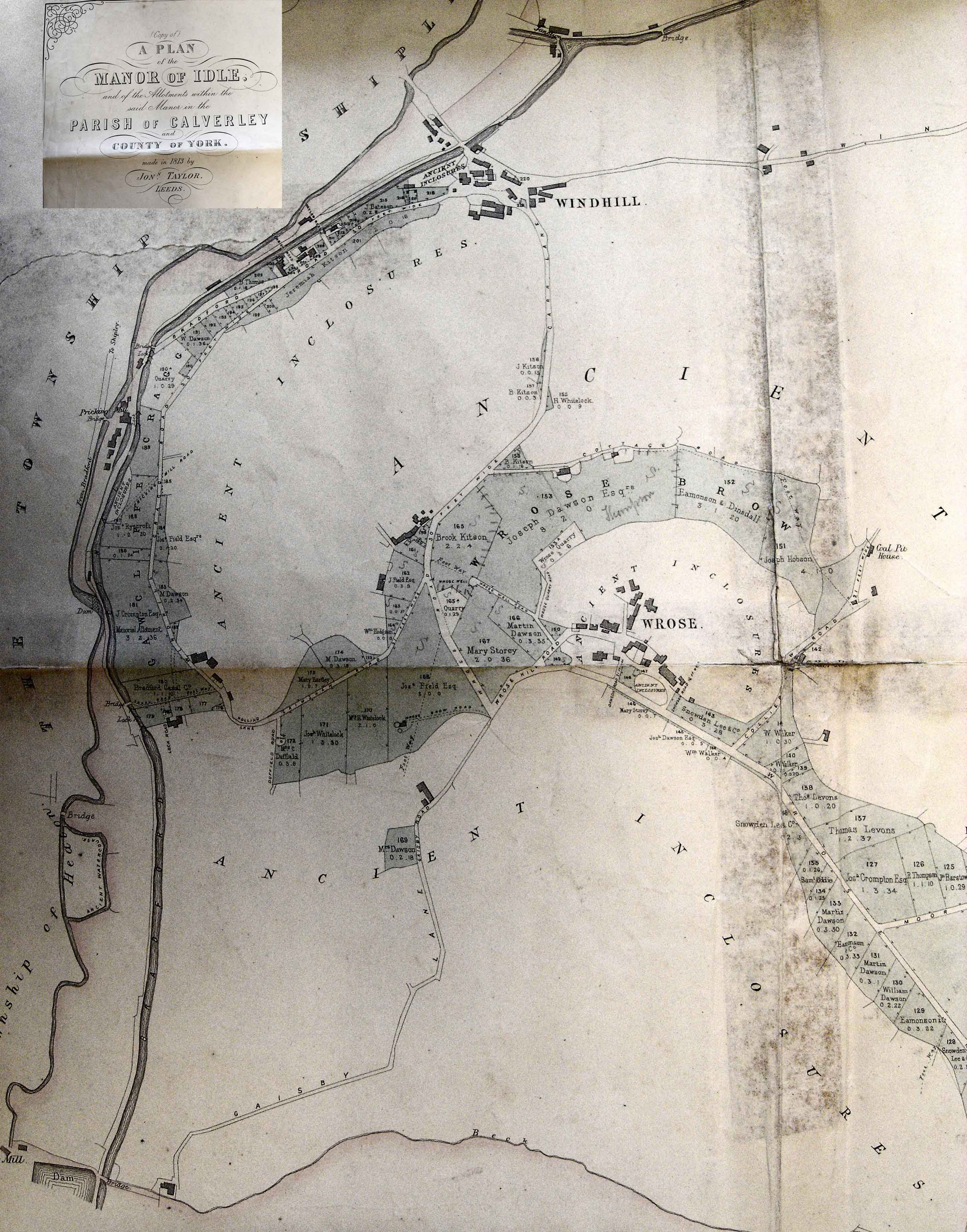
Greenwood in 1814. P - Plot 196 Plot
196, of 19 perches, was allotted to Benjamin Thomas in 1813. In 1814
Absolam Rangeley (or Rawnsley, a brother-in-law of Joseph Bateson) was the
tenant. Q - Plot 197 Plot
197, of 5 or 8 perches in 1813 (both figures were given), was allotted to Henry
Wright Dawson, who owned a considerable amount of land in Idle. In a
Lease and Release dated 11 and 12 January 1813 the plot was “Lately enclosed from the Commons & Waste
Grounds & allotted to Henry Wright Dawson in respect of his ancient rights
within the said township of Idle and contains by estimation 8 perches”. The Deed
noted a “Tenement lately erected upon
the said piece or parcel of ground and now used as a School”. The conveyance was to a consortium of 5 men:
Samuel Cowling, Thomas Stead, Joshua Taylor, Benjamin Harrison and Joseph
Bateson. These
gentlemen were the Trustees of Windhill School, one of the earliest to be
established in Windhill itself. According
to Cudworth, the School was built in 1811 and opened in March 1812. The first schoolmaster was Matthew Thompson,
then Moses Henry Lee, a returning Idle native, arrived to take up the post
between 1814 and 1816, followed by Matthew Thompson and John Clough. R - Plots 216 & 217 Plot
216, of 17 perches, was allotted to Joseph Naylor in 1813. Plot
217, of 16 perches, was allotted to William Naylor. Around
1837 some of this ground was donated or sold to the Wesleyans for the
construction of a Sunday School, with an access road, next to their Mission
Hall. S - part of Plot 201
Plot 201, a long strip of land of over 2 acres bordering the east side of Briggate,
was allotted to Jeremiah Kitson in 1813. In 1814 it was known only as an ‘Allotment at Windhill’.
Kitson (both father and son were called Jeremiah) also owned all the adjacent land to the east, on the steep ground between Windhill Crag and Wrose.
“situate lying and being on the north east side
of the house”
(ie the house he bequeathed to Henrietta Maria Peel – Crag Cottage).
This places the land in question on the E side of Briggate, roughly where the Church, Vicarage and Observatory were later built.
The assumption is that William Peel purchased or leased the ground from James Bateson.
T - part of Plot 201 In 1964,
when Shipley UDC bought Crag Cottage from Peel's grand-nephew, Charles
Stancliffe, a 140 square yard plot on the east side of Briggate just south of a
footpath leading to Peel Place (where Owlet Nursery now stands) was included.
William Peel may have once owned this piece of ground. U - land possibly owned in 1869 by James Bateson (b 1794 or his son b 1824).
See S above. Footnotes: Enclosure
was the process by which
open fields, common grazing land and areas of waste ground were marked off and
made into 'closes'. One ostensible
reason was to improve the land and so help to feed an expanding
population. Sometimes the less explicit
reason was to exploit, and profit from, mineral resources such as coal,
although there is no evidence that this was the case in Windhill. Enclosure could also be a means of getting
rid of burdensome tithes: occasionally, an allocation would be given in lieu of
certain rights such as a right to tithes.
The minute books of the
meetings of the Idle Inclosure Commissioners, which might have given details of
negotiations, objections, sales and exchanges of land, do not appear to have
survived. All that is known is that
the process began with an invitation to interested parties to attend a public
meeting at the White Bear Inn in Idle on the last day of 1808; it continued with a
meeting at the Manor House in 1809 “
for
the purpose of reading over, settling and signing the Consent Bill to be
presented to Parliament for the Division and Inclosure of the Commons and Waste
Grounds”; a
meeting at the White Bear on 14 May 1810 was called to allow people to make
objections to the Commissioners’ proposals for roads and footpaths; the process
ended on 12 May 1814 at the Red Lion, when the Award was read out. To accompany the Award, the
Commissioners produced a plan of the manor, the western part of which is
reproduced
here.
The Plan shows that
their awards for west Windhill, shaded grey, were in a narrow band
following the line of the Bradford Canal. Further east, the
allocations
encircled Wrose village, covering the steep flank of Gaisby Hill, the quarries
above Carr Lane and the Wrose Brow woodlands. Everywhere else in Windhill was
blank on the Plan and was labelled 'Ancient Inclosures'. This tells us that the
process of enclosure in Idle began much earlier, in medieval times in fact. By
the end of the 16th century, most of the Manor, including some of the common
grazings, had been enclosed, the exceptions being Gawcliffe Crag, parts of Idle
Moor and Wrose. The 1813 Inclosure Award concluded the process by enclosing the
steepest, roughest and least productive land.
Joseph Bateson received
an award of 3 enclosures in 1813. The Commissioners seldom
gave reasons for their allocations but one that was noted was an award to a
Henry Ovington “in right of his own fee
simple estate”.
Presumably, Joseph Bateson and others
received their allocations for similar reasons. This means that Joseph
must have been an existing freeholder, though the location and nature of his
holdings are uncertain. What is known is that in
1804 and 1811 he bought cottages and land in Windhill from John Thornton and
George Wright respectively. Of the three enclosures
allotted to Joseph in 1813, two (Plots 209 and 215) were apparently purchased
from previous owners (Joshua Taylor and John Denby respectively). In the case of the
former, the commissioners wrote (my italics): “..all
that other allotment, piece or parcel of ground purchased by the said
Joseph Bateson of Joshua Taylor situate at Windhill Crag and marked on the said
Plan with the Number 209.”
It may be that Joshua
Taylor learned he was to be allocated Plot 209 but decided he did not want it.
Before the Inclosure Award was written up and published, he may have sold it on to
Joseph Bateson, who thus became the allotted owner of the plot, with all the
associated responsibilities. The disposal of allocated
land before formal notification may have been a fairly common practice in
Idle: John Bakes, John Hornby, John Pitts and Abraham Stansfield were other
purchasers of land that was originally awarded to someone else. By this means, small
parcels of low quality or inconveniently located land could be sold on and
amalgamated into larger, more efficient holdings. Note on measurements: The 1891 1:500 OS Plan
was used as a baseline to check the dimensions of certain plots on maps printed
in 1813, 1838 and 1847. Two reference points, which appear in all the maps,
were chosen: the length of the old Water Pitts building west of the canal and
the width of the Bradford Canal itself.
The frontages onto Bradford Road (Briggate) of all the plots from Taylor
Road (later known as Water Lane) as far as the Methodist Mission Hall were then
measured and compared and any discrepancies calculated. The results showed that,
with some exceptions, the maps are roughly in accord – to within 20%. However, a Plan produced
by Jonathan Taylor in 1813 for the Inclosure Notice places Taylor Road about 7
yards further to the N than the other maps. This, surely an error, was
corrected in a map produced by Taylor in 1814 to accompany his Survey and
Valuation of Idle. The dimensions of Plot
215 (as measured on the 1813 Plan) correspond to the area (2 roods) given by
the surveyors in the Survey report. However, the length of
the Briggate frontage of Plot 215 (as given by the 1813 and 1814 Plans) is
about 15% greater than on the 1891 OS Plan. References: * Deeds referred to are
available as Memorials at Wakefield Registry of Deeds * The Will of Joseph Bateson is at the Borthwick
Institute * ‘A Plan of the Manor of Idle drawn up between
1810 and 1813’ by Jonathan Taylor (one of the Inclosure Commissioners, the
other being Jonathan Teal) - in West Yorkshire Archive * ‘A Survey and Valuation of the Township of Idle’
by Jonathan Taylor, 1814 - in West
Yorkshire Archive * Advertisements were placed by the Commissioners
in the Leeds Mercury in 1808, 1809, 1810 and 1814 * ‘A
Plan of the Township of Idle, Copied and Enlarged from a Map made by the late
Jonathan Taylor in AD 1814 with the Alterations to December 1838’ by Lister
& Ingle - in West Yorkshire Archive * 1584 ‘Map of the Lordship of Idle’, adapted by
Martin Bradley * 1847 1:10560 OS map * 1891 1:500 OS Plan * 1934 1:2500 OS map * J A Stevenson: ‘Round About Windhill’, 1960 - a
typescript seen at West Yorkshire Archive, Bradford * Auction of Freehold Property at Windhill, at Sun Hotel, Shipley on 7 Dec 1869,
by Weatherhead & Burr, solicitors * Milton Hudson: ‘1834-1919 Windhill Wesleyan
Mission - Its 19th Century Origins’ in 'Windhill Wesleyan Mission
1835-1961' by Arthur Costigan, page 15, published by NE Windhill Community Association
1989 © Windhill Origins 2019 |